#hikerchat - Adventure Planning
HikerChat

 TETONsports
 MissouriHowell
replying to @TETONsports @TETONsports A5: CalTopo for paper maps and Gaia GPS for phone. #hikerchat
 RMhigh7088
 HikingWithHendr
replying to @TETONsports @TETONsports A5) AllTrail is definitely my go to! #hikerchat
 InnTownCamp
replying to @TETONsports @TETONsports a5: I'm excited to tag along, the next Folk Trails Hiking Club is next week and it leaves from the cam… https://t.co/qHQymQZbdf
 X2JHiker
replying to @TETONsports @TETONsports A5 I use AllTrails, Google Maps, and REI's app #hikerchat
 mjn126
replying to @TETONsports @TETONsports A5: Google Maps, REI Hiking Project, ViewRanger. I have not been anywhere too complicated yet in my… https://t.co/bLY9mJXE7m
 afoxintheforest
replying to @TETONsports @TETONsports A5). Meg checking in! I use a good old paper map and compass combined with the topo maps + app. Love it! #hikerchat
 bushwhackingfoo
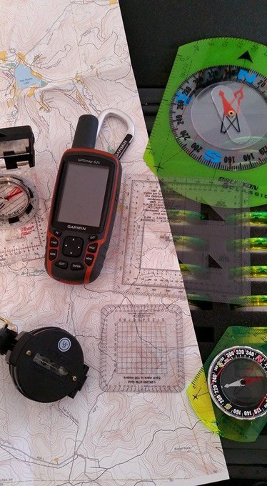
replying to @TETONsports @TETONsports A5. For trails? Nothing but a map. For bushwhacking? Garmin GPS, maps & aerial photos. #hikerchat
 bill_thegearguy
replying to @TETONsports @TETONsports A5 a good topo map in color and a compass. I've gotten pretty good at just using terrain association.… https://t.co/jEjsJKLTi2
 RCGibby73
replying to @TETONsports @TETONsports A5: I've found All Trails to be handy and am finding out about other apps as we chat! #hikerchat
 WeekendWomanWar
replying to @TETONsports @TETONsports A5: I only use the sun and the stars for navigation. I'm old school that way. Also get lost a lot. 😜 #HikerChat
 billbrokob
A5: Gaia and topo maps. I usually search for trip reports to get a feel for the terrain #hikerchat
 TheSoCalHiker
replying to @TETONsports @TETONsports A5: I use https://t.co/ZhyF8EZlnR for planning and @GaiaGPS for navigating and recording my path. #HikerChat
 3UpAdventures
A5 I really love GaiaGPS for my phone. I used CalTopo alot for pre hike research #hikerchat
 kevinspocket
replying to @TETONsports @TETONsports A5: I love my @nynjtc trail maps - favorite gps app is MotionX GPS 👍 #hikerchat
 Todd_the_Hiker
replying to @TETONsports @TETONsports #HikerChat A5. Paper maps always along with my @Garmin GPS apps and various online map sources.
 danielhuman
A5 #hikerchat I just carry a backpack full of navigational equipment and a briefcase full of compasses.
 MomsWanderlust
A5: We plan them before we leave. Hiking with the kids means we go hard, but stay on trails that we are not in dang… https://t.co/uZz8ibMahB
 t_jh2009
replying to @TETONsports @TETONsports A5) I'll use my @ParksPassport app to help find a trail in a @NatlParkService area but go old school w… https://t.co/NbadiXdOGY
 AvenzaMaps
 k2rm
k2rm
replying to @3UpAdventures @3UpAdventures A5: I have not heard of that. Looking it up presently. Thanks! #hikerchat
 paulina_dao
replying to @TETONsports @TETONsports A5: I use Caltopo a lot. Took a map and compass class this year and prefer navigating that way. Plus m… https://t.co/3hN9mpdy99
 dignthegarden
replying to @TETONsports @TETONsports A5 - Love all these answers. New things to try! #hikerchat
 Parks_Explorer
replying to @TETONsports @TETONsports A5. @Parks_Explorer to check out terrain, top #hiking trails in #VR or #immersive video & google maps… https://t.co/jRBVTcVx56